SAR Analytics for Southeast Asia's Changing Environments

We build satellite-based intelligence tools for governments, infrastructure operators, and asset managers with real exposure to ASEAN's tropical landscapes, where generic remote sensing pipelines consistently fall short.
Where We Focus
SAR imagery penetrates cloud cover year-round, a decisive advantage in tropical ASEAN, where optical sensors are routinely unusable. We build operational pipelines for three problem areas where this matters most.
| Urban Subsidence & Infrastructure Risk | Tropical Deforestation & Land Use Change | Maritime & Coastal Monitoring |
|---|---|---|
| Continuous ground deformation monitoring in high-density Southeast Asian cities. Jakarta, Bangkok, Manila, and Ho Chi Minh City are among the fastest-subsiding urban areas in the world. | Cloud-penetrating change detection for plantation monitoring, carbon credit verification, and land use compliance, where optical imagery fails for months at a time. | Shoreline dynamics, port activity, and coastal infrastructure change tracking across Southeast Asian waters and island environments. |
| Municipal governments Property developers Infrastructure insurers | Plantation operators Carbon verifiers Forestry agencies | Port authorities Maritime agencies Coastal insurers |
A Specific Combination That's Genuinely Rare
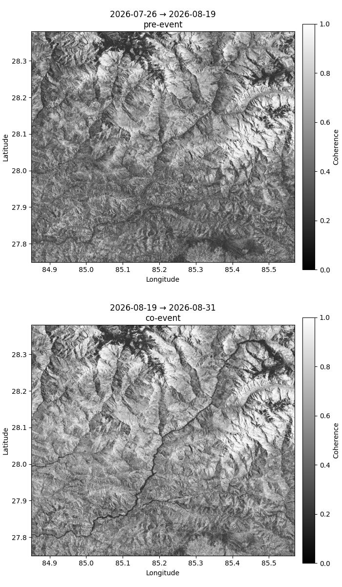
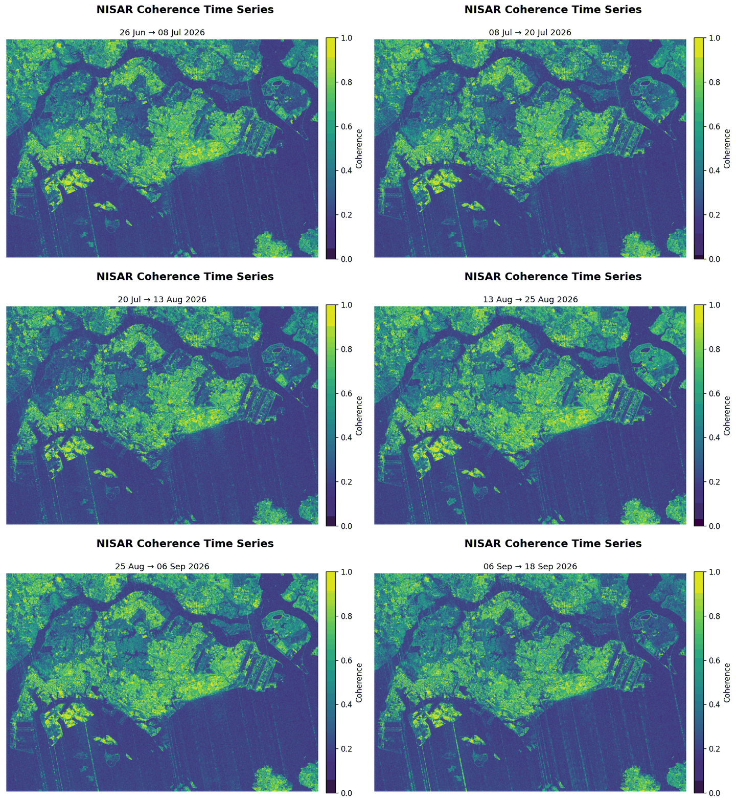
SAR data has been commercially promising and operationally disappointing for decades in tropical ASEAN, not because the physics is wrong, but because machine learning models trained on temperate, well-labeled datasets fail in the tropics. Cloud cover, high humidity, dense vegetation, and fast-changing land surfaces create conditions that standard pipelines are not built for.We address this at the model level, using self-supervised learning to remove dependence on large labeled datasets, and coherence-based change detection to capture dynamics that amplitude-only pipelines miss.That technical foundation is paired with something less common in deep research: the ability to translate findings into operational language that procurement officers, risk managers, and government agencies can act on.
Engagement Model
Our R&D Process
Problem Discovery
We begin by understanding the operational decision your organisation needs to make, not the data you have, but the outcome you're trying to reach. This includes scoping the problem, validating whether satellite data can address it, and defining clear success criteria before any development begins.Proof of Concept
A bounded, time-limited analysis or prototype that tests feasibility on real data from your region of interest. Deliverable is a technical brief and demonstration, enough to support an internal decision on whether to proceed. Fixed scope, fixed fee.Operational Deployment
Transition from prototype to a repeatable, maintained pipeline delivering regular outputs to your team. We handle data acquisition, processing, and interpretation, you receive analysis-ready results on the cadence that matters for your operations.
Our Fees
Proof-of-concept engagements are priced on a fixed-fee basis, scoped before work begins. Ongoing operational engagements are structured around the value delivered, typically a retainer or milestone-based arrangement aligned to the outputs your team actually uses.We do not bill by the hour. Initial conversations are always without obligation.
About Us
Yuki Natsume is an applied machine learning researcher and practitioner specialising in SAR remote sensing for Southeast Asian environments.He is currently completing a PhD in machine learning and remote sensing at Nanyang Technological University, Singapore, where his research focuses on deep learning models for SAR change detection, specifically addressing the labeled data scarcity problem that limits operational SAR analytics in tropical regions.Prior to doctoral research, he held a senior consulting role at KPMG Japan and completed graduate training in Earth and Planetary Science at the University of Tokyo. He has seven years of experience spanning research, data science, and analytics consulting across Japan, and is proficient in English and Japanese.Natsunoyuki AI Lab was founded to bring research-grade SAR methodology to organisations with practical exposure to the problems it can solve.
Applied Work
Representative analyses demonstrating our technical capability. Each uses SAR data from Sentinel-1 or equivalent platforms; none require cloud-free conditions.
Flood Mapping

Automated flood extent detection from Sentinel-1 SAR imagery. SAR penetrates cloud cover year-round, enabling all weather 24 hour reliable flood mapping in tropical environments where optical sensors are frequently unusable.
Land Use Land Cover Segmentation

Land use and land cover segmentation from Sentinel-1 SAR imagery. Pixel-level classification of surface types across large areas, without dependence on cloud-free conditions.
Contact Us
Please submit your queries using the form below. A representative will follow up with you shortly.
PeekingDuckReborn: Low Code Computer Vision
PeekingDuckReborn is a modernized evolution of PeekingDuck, an open source, modular Python framework designed for computer vision inference. Originally developed by AI Singapore, PeekingDuck offered a low code approach to building vision pipelines. However, the original project is no longer maintained and has become incompatible with modern Python libraries and tooling.We created PeekingDuckReborn to revitalize this powerful idea, bringing it up to date with modern libraries, improved performance, and long term maintainability.
A Low Code Modular Framework for Vision Inference
PeekingDuckReborn provides a modular, low-code framework for deploying customizable computer vision pipelines without writing extensive inference or visualization code for:
1. Object detection and tracking,
2. Pose estimation,
3. Zone-based logic and analysis,
4. Live video or image input/output,
5. Real-time overlay visualization,
Rapid Pipeline Creation with YAML
For example, a pipeline to detect, track, and visualize the positions of cars on a busy street can be assembled with just a few lines of YAML configuration:

Visual Example: Real Time Traffic Monitoring

This inference result was created without writing any inference logic or drawing code, just declarative YAML configuration. PeekingDuckReborn handles the rest.
Different functionalities such as object detection, object tracking, and zone-based crowd analysis can be easily mixed and matched to support a wide range of use cases.
Open Source and Actively Maintained
PeekingDuckReborn is fully open source and freely available on GitHub. It is actively maintained with support for modern Python libraries, improved tracking algorithms, clearer visual outputs, and better runtime compatibility.⚠️ Note: The original PeekingDuck project by AI Singapore is no longer actively maintained and may not work with modern systems. PeekingDuckReborn is a modern, independent fork designed to carry the project forward.